
Try it with sound on.
What is DAS?
Beneath the world’s oceans lies a vast network of fibre-optic cables that carry our internet and communications between continents. Distributed Acoustic Sensing, or DAS, is a technology that allows these same cables to double as sensors.
DAS works by sending rapid pulses of laser through a fibre-optic cable. When sound waves or vibrations pass through the surrounding environment, from ships, whales, earthquakes, or moving seafloor, they cause tiny changes in the light travelling through the fibre. By measuring these changes, DAS can detect and locate acoustic signals along the entire length of the cable, often over hundreds of kilometres.
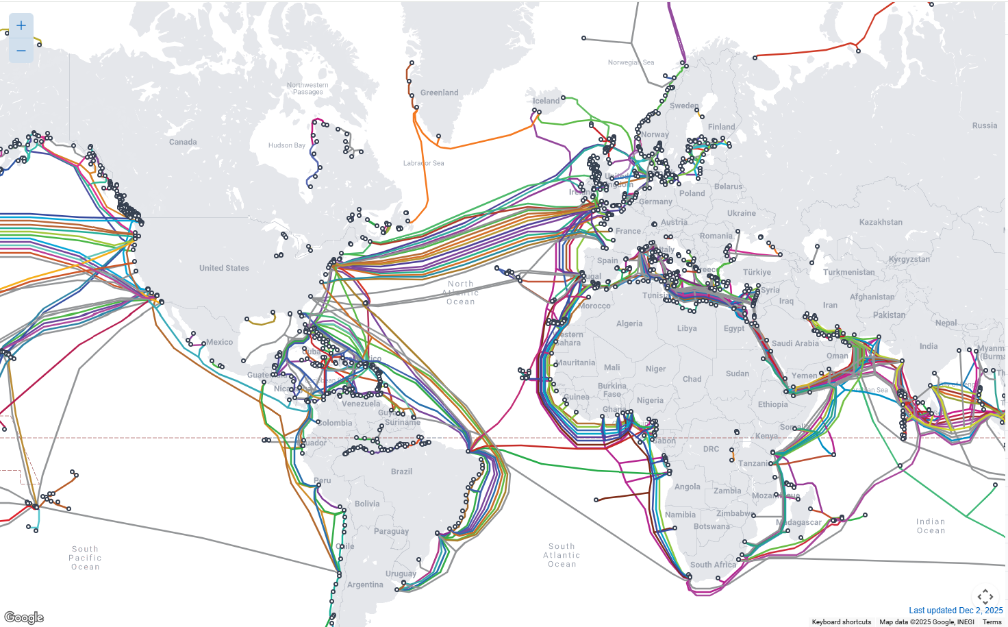
Click the map to explore the globe’s network of submarine cables!
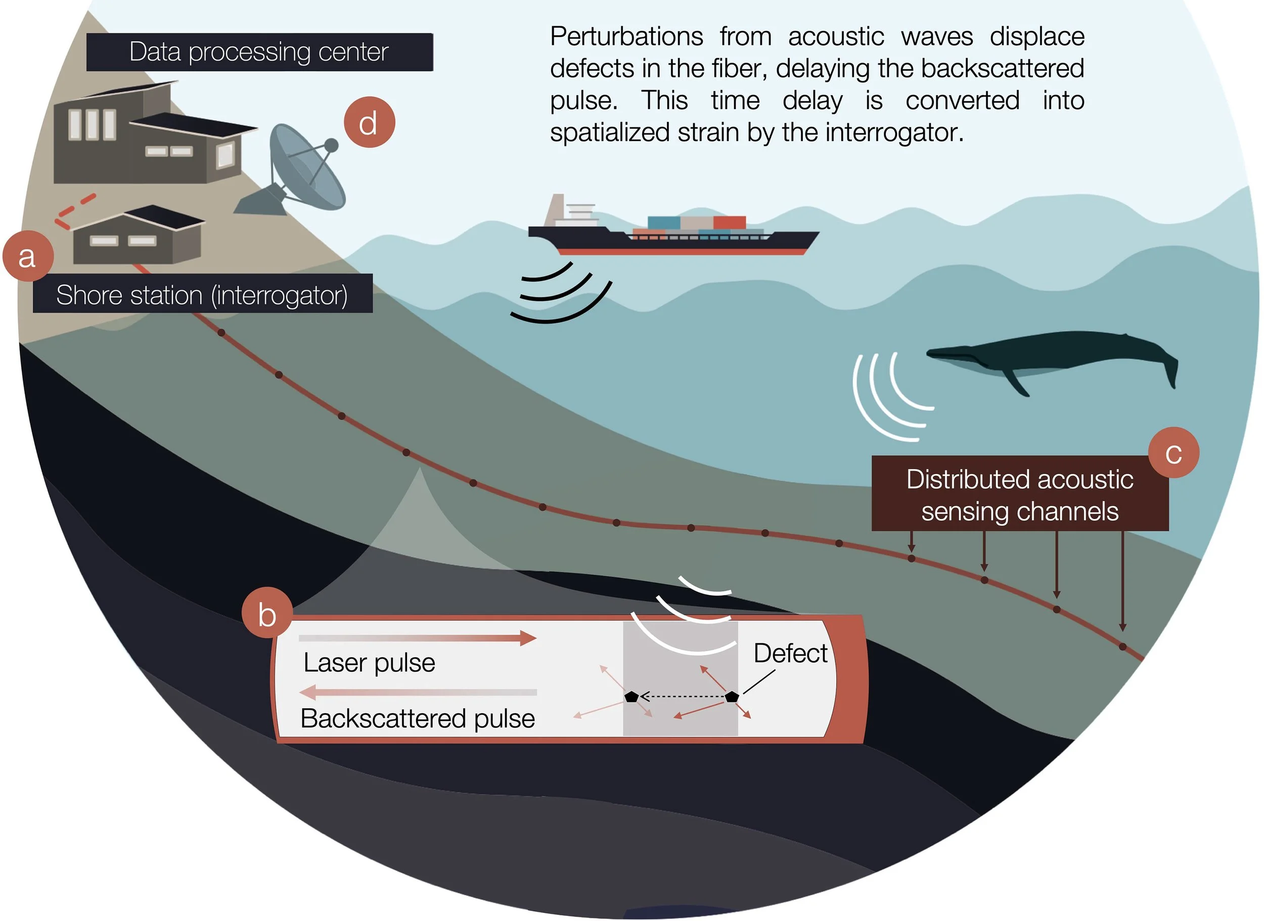
Figure from https://doi.org/10.3389/fmars.2022.901348
Unlike traditional ocean monitoring tools, which rely on individual instruments placed at specific locations, DAS creates a continuous listening system. This means the ocean can be monitored in real time, across large areas, using infrastructure that already exists on the seabed. Because no new sensors need to be deployed, DAS is cost-effective, scalable, and environmentally non-intrusive.
In ATLAS, DAS transforms submarine telecommunication cables into novel sensors providing critical information for marine conservation, maritime safety, and natural hazard monitoring across the Atlantic.
Marine Mammal detection
Many marine mammals depend on sound to communicate, navigate, and find food. However, busy shipping routes increase the risk of ship–whale collisions, particularly in regions where whale habitats overlap with heavy maritime traffic.
Using DAS, ATLAS can detect the low-frequency vocalisations of large whales as they travel through the ocean. Because these sounds propagate over long distances, fibre-optic cables act like extended acoustic arrays, capturing whale presence over wide areas rather than at isolated points.
This continuous monitoring helps scientists understand when and where whales are present and how they move through key regions. When combined with automated detection and alert systems, DAS data can support real-time warnings to vessels, reducing collision risks while improving protection for endangered species.
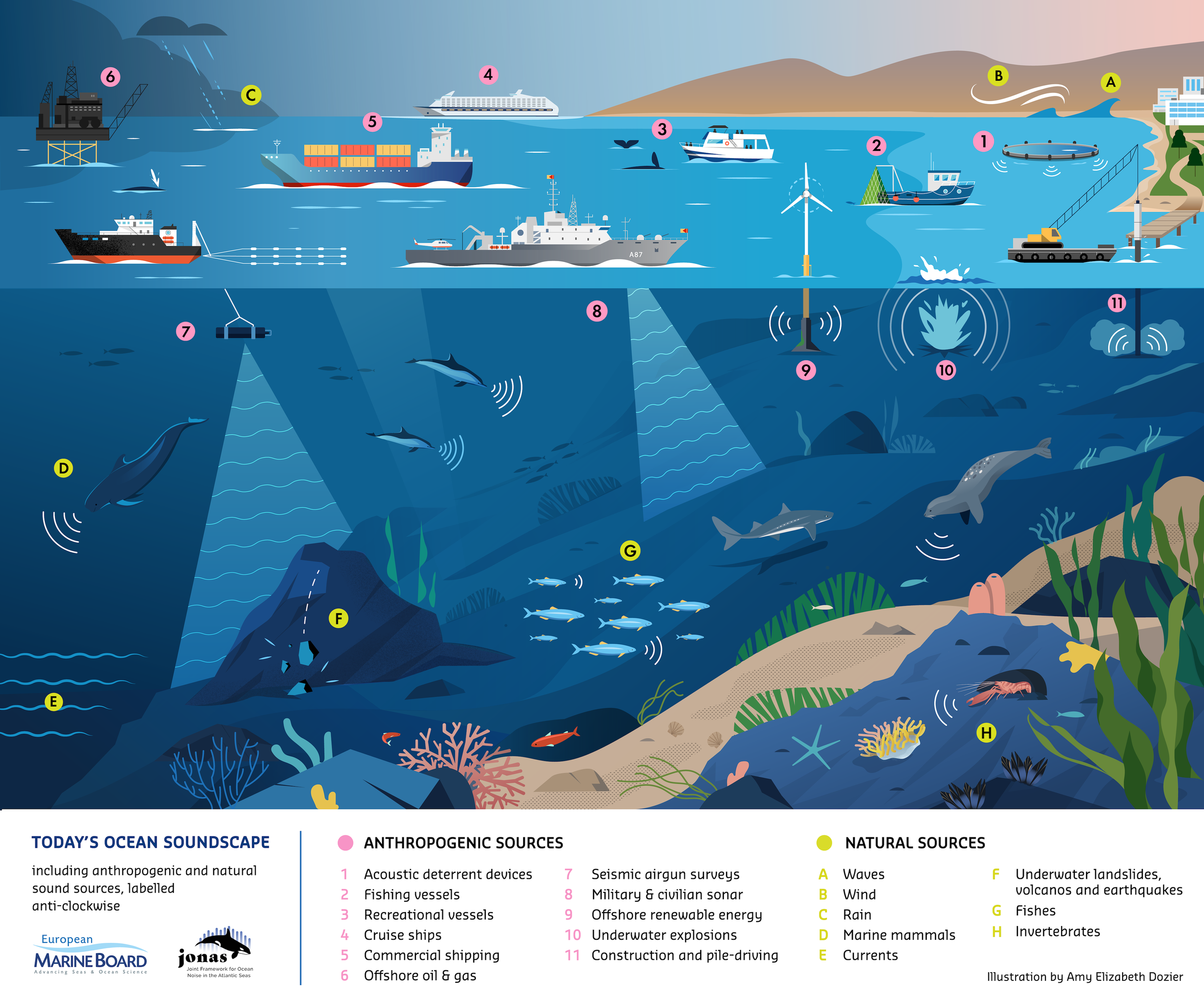
Ship noise monitoring
Modern oceans are increasingly affected by underwater noise from ships and other human activities. This noise can disrupt marine life, mask animal communication, and alter natural behaviours. Monitoring underwater noise is therefore a key requirement of European marine environmental policy.
ATLAS uses DAS to measure shipping noise continuously along submarine cable routes, creating maps of where and when noise levels are highest. Unlike traditional monitoring methods, which offer limited coverage, DAS provides a long-term, large-scale view of the ocean soundscape.
By linking DAS data with ship traffic information, ATLAS can identify how different vessels and routes contribute to underwater noise. This knowledge supports evidence-based decision-making for regulators, ports, and the shipping industry, helping to reduce noise impacts while maintaining safe and efficient maritime transport.
Seismic detection
Many earthquakes and underwater landslides occur far offshore, beyond the reach of land-based seismic stations. These events can threaten coastal communities, damage submarine infrastructure, and trigger tsunamis, yet they are often detected late or with limited detail.
With DAS, submarine fibre-optic cables become sensitive detectors of ground motion on the seafloor. ATLAS uses this capability to identify seismic events in real time, extending monitoring into areas of the ocean that were previously difficult to observe.
By strengthening offshore earthquake detection and integrating with existing warning systems, ATLAS improves our ability to assess risks, protect critical infrastructure, and respond more effectively to natural hazards in the Atlantic region.
Our test sites
ATLAS will be develop DAS monitoring across three test sites of different spatial scales, enabling the technology to be validated under a wide range of environmental and operational conditions while reflecting the diversity of the Atlantic Area. At the smallest scale, SMART Bay in Ireland provides a high-resolution coastal test site, where DAS measurements can be closely validated against existing oceanographic and acoustic instruments. The Aguçadoura site in Portugal represents a medium-scale deployment, extending monitoring further offshore and capturing a broader range of shipping activity and environmental variability. At the largest scale, the Canary Islands site, using submarine cables operated by CANALINK, enables long-range DAS monitoring over tens to hundreds of kilometres in a region characterised by intense maritime traffic, rich cetacean biodiversity, and significant seismic and volcanic activity.
SMART Bay Ocean Observatory,
Galway Bay, Ireland
Small scale, high resolution data
5.3km submarine cable
23m depth
INESCTECH,
Aguçadoura, Portugal
Medium scale, mid range depth and distance
50km submarine cable
50m depth
CANALINK,
Canary Islands, Spain
Large scale, profound depth and largest distance
Two submarine cables to be tested
222km & 173km submarine cable
2650m & 3,570m depth
Together, these sites form a complementary transnational test network spanning multiple EU Atlantic Area regions. By linking infrastructure and expertise across Ireland, Portugal, and Spain, ATLAS demonstrates the value of cross-border collaboration between European partners in addressing shared marine challenges. This coordinated approach strengthens ocean observation at the Atlantic scale, supports EU environmental and risk-prevention objectives, and sets the foundation for future expansion of DAS-based monitoring across European waters.